MYSTERIES OF GHANCHAKKAR(1532 m) MAHARASHTRA'S THIRD HIGHEST MOUNTAIN REVEALED FINALLY .
Long Long Exhausting, dehydrating and tiresome trek of Bhairavgad -Ghanchakkar -Muda
Well till now very few blogs/websites has given information and photos of this mountain.Well I have tried maximum to give all possible useful information about Ghanchakkar.Ghanchakkar is not popular amongst trekkers because of no shelter and water source for too many kilometers hence many trekkers skip it.Some trekkers who do the trek from Bhairavgad to Ratangad only trek Ghanchakkar-Muda mountain
The villager accompanying me was saying that I was the only person in the last 2 years to reach this mountain.Earlier,many people used to trek it.In the trekking season,around 20 to 25 people used to visit this mountain but past few years,other than local villagers,very few people are visiting Ghanchakkar-Muda. This itself shows how much neglected is this mountain.
Local villagers use this mountain as a source of firewood and dried grass,and 4 caves on Ghanchakkar are used as shelter for cattle hence it is full of cowdung and not a place of shelter anymore and also these caves are at a odd and difficult location on the route to Bhairavgad.
Hence due to such conditions,there are no wild animals like leopards,foxes, wild pigs etc in this region (Obviously it is difficult for any animal to survive in such conditions)
I did Ghanchakkar(1532 meters) and Muda(1520 meters), returned through Bhairavgad(1175 meters) towards Shirpunje Ashram-Shala plus there was no ST bus in evening to return back hence I have to traverse the Pathar mountain in front of Ghanchakkar mountain and after that again climb Half Pabargad(1375 m), traverse and reach Guhire village and reach Randha falls to get a Jeep till Akole and after that I was lucky to get the 6:30 pm bus to Pune from Pune(This bus is sometimes available in some festive seasons maybe since Mahashivratri is coming near hence it might be for people going to Harishchandragad.After last bus of 3:00 pm,there is no bus to Shivajinagar available from Akole.)
Ghanchakkar and Muda Plateau has got lot of crystals of Topaz (पुष्कराज ) , Quartz and Mica, flintstones (hundreds and thousands truck can be filled) .At some places there were crystals of such size that it is difficult for even two people to lift that crystal stones .Any rock you break,you will find crystals in it.
Ghanchakkar(1532 m) and Muda(1520 m) are Maharashtra's third highest and fourth highest mountains respectively after Kalsubai(1648 meters) and Salher(1567 meters)
Ghanchakkar and Muda mountains are at an odd location plus barren and scarcity of water having a long plateau hence they are neglected by trekkers.These mountains are located in the following order from the main sahyadris (Ratangad(1297 m)->Katra(1408 m)->Wakri(1100 m) ->Muda(1520 m) ->Ghanchakkar(1532 m)->Bhairavgad(1175 m) )
Ratangad and Katra is in main Sahyadris while the other mountains including Ghanchakkar Muda are the ranges running from west to east till Bhairavgad forming a small mountain range from Katra to Bhairavgad
Ghanchakkar and Muda doesnt have any place for Shelter and also lack of Potable water sourcec thus at the end of winter season, it is totally barren
Basically Ghanchakkar is a long long plateau of approx 10+ kms with Ghanchakkar and Muda the two highest points on this plateau and further this plateau descends towards Kumshet the base village to Ajoba and Katra mountains towards the Ratangad-Harishchandragad trek route
Base village of Ghanchakkar: Shirpunje( शिरपुंजे बुद्रुक ) or Shirpunje wadi
From here,Ghanchakkar is approximately 750 to 800 meters high( 1.5 times higher than Torana fort)
How to reach Ghanchakkar base village
Take the 4:00 am bus from Shivajinagar Pune to Kalwan and reach Sangamner till 7:30 am.Take a Jeep/Bus till Akole (अकोले ) or Rajur
I missed this bus but I was lucky to catch it at Rajgurunagar.I followed on my bike till Rajgurunagar ,parked my bike near ST bus stand at Rajgurunagar and boarded this bus till Sangamner.Further I got a Kasara bus to reach Rajur
Reach Rajur (राजूर ) before 9:15 am.There is a bus to Kumshet(Akole to Kumshet ST bus) around 9:30 am (कुमशेत ) going via Shirpunje, Ambit (अम्बित ) Jaaneadi ( जानेअडी ) leelakhed (लिलाखेड ) till Kumshet
Get down at Shirpunje Ashramshala (शिरपुंजे आश्रमशाळा ) near Shirpunje Khurd and walk 3 kms approx till Shirpunje Budruk .At the end of Shirpunje Khurd village,you will have the route going towards Bhairavgad to the left whereas for Ghanchakkar,you have to walk further till Shirpunje Budruk or Shirpunje Wadi (शिरपुंजे ची वाडी ).
Ask anybody for the route to Ghanchakkar in this village.Anybody will guide you.In this village,you will see a small Hanuman temple built.From this Hanuman temple,take left towards fields and small houses and you will find a long arm of Ghanchakkar coming down in this village across the fields.This is the route to reach the top.( घनचक्कर पर्वताचा एक लांबलचक उभा दांड शिरपुंजे वाडी नजीक च्या शेताजवळ उतरलेला आहे .तोच उभा दांड तुम्हाला घनचक्कर च्या पाठरामध्ये आपल्याला घेऊन जातो .तुम्हाला २० किलो मीटर पर्यंत कोठेही पाण्याचा स्त्रोत सापडणार नाही त्यामुळे शिरपुंजे वाडी गावातूनच भरपूर पाणी भरून घेणे .वास्तविक घनचक्कर चा ट्रेक जास्त अवघड नाही पण पाणी भरपूर घेतले पाहिजे कारण वाट चुकली तर तुम्हाला भरपूर पाणी आधार देऊ शकते त्यामुळे प्रत्येक माणसा मागे कमीत कमी ५ लिटर पाणी तरी घेणे . त्या शिवाय पर्याय नाही )
From this shoulder,a long,steep and exhausting climb of 1.5 hours through thick dense trees and sometimes through barren hills, takes you top the Ghanchakar Plateau .From here you will see a long long plateau and a long plod of around 30 minutes takes you to the Ghanchakkar top.Further a long walk of 1 hour takes you to the Muda top
The Ghanchakkar Muda top is completely barren with no trees hence it is rather unpleasant in such season .Best season is only in 2 months of winter season.
In rainy season also it cant be trekked because Ghanchakkar is not a fort hence you will not see steps leading till the top (या डोंगरात कोणताही गड अथवा किल्ला नाही कि कोणतेही धार्मिक ठिकाण नाही त्यामुळे येथे पायऱ्या सापडणार नाहीत. एका लांबलचक धोपट पाउलवाटेनेच तुम्हाला घनचक्कर च्या पठारात पोहोचावे लागेल )
It also has very very confusing routes hence it is advisable to take any local guide .In my case, students of 8th standard studying in Ashram shala of Shirpunje village were also interested in coming up to Ghanchakkar (जेव्हा त्या आश्रम शाळेतल्या मुलांना कळले कि मी पुण्याहून एवेढ्या लांब घनचक्कर साठी आलो आहे तेव्हा त्या लोकांनी सुद्धा माझ्याबरोबर येण्याची तयारी दाखवली ) there and also further I was accompanied by two more villagers of Shirpunje Wadi village hence we were altogether 6 people now.
We reached the top of plateau in 1.5 hours and a long walk of around 45 minutes,I reached Ghanchakkar top.Two people from Shirpunje wadi village told that they will be collecting fire wood and dry grass here hence they showed me the route to Muda and told me that they will again meet me at the same place.
After having some views from Ghanchakkar top,I headed towards Muda top.
Views from Ghanchakkar
To the north,you can see Pabargad, Kalsubai , Alang , Madan, Kulang and a vast Bhandardara lake(The huge Bhandardara lake looks like star shaped.This shape can be only seen from Ghanchakkar-Muda and from nowhere else.Not even from Kalsubai)
To the west,you can see Neighboring Muda,Ratangad,Katrabai,Ajoba,Napta
To your south,you can see Harishchandragad, Karkai dongar, Kaladgad and some awesome mountain formations near Kumshet plus if weather is clear,you can have a view till Nane Ghat
To your east,you can see the vast Plateau of Ghanchakkar and since neighbouring Bhairavgad is very small as compared to Ghanchakkar hence it cannot be seen.
For Muda(1520 m)
You have to traverse the Ghanchakkar top and climb down a little bit and you are in the Plateau of Muda.Now after a long walk of around 45 minutes to 1 hour you will reach the Muda top but since it was already 1:30 pm and too much of heat plus out of my 3 bottles of water,1 full bottle and one half filled bottle was remaining and hardly 25 to 50 meters of Muda was remaining but it was a 2 kms walk on that barren mountain and I had to travel back with less water.Hence after reaching nearby final climb of Muda top,I had views of Bhandardara dam ,the surroundings and started coming back
In 30 minutes again I reached Ghanchakkar.Took some snaps of surroundings and after that decided to proceed back
After climbing down half of Ghanchakkar,there is a tricky route to Bhairavgad which in 15 minutes takes you to the steps of Bhairavgad.But beware of loose soil near cave of Ghanchakkar and now this route is full of dried cowdung plus this route is very narrow hence after crossing this patch carefully,you reach Bhairavgad through thick dense bushes.
Actually if local people were not there,I could not have found this route
From Bhairavgad, you can descend down to the Shirpunje Khurd village through an easy route and reach the Shirpunje Ashram Shala
But after reaching Shirpunje Khurd village around 2:30 pm,I came to know that there is no ST bus to go to Akole hence again I had to climb up the Pathar mountain ,traverse itand reach the halfway of Pabargad and traverse it to reach down at Guhire (गुहिरे ) village and further to Randha falls.It was a 6 kms walk and from there ,I got a jeep till Akole
Further around 6:30 pm,I got a bus to Shivajinagar to reach Pune around 10:30 pm after a long exhausting dehydrating and tiresome trek
Here are the photographs
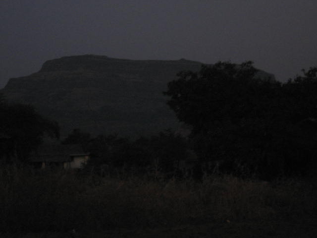
1) View of Ghanchakkar on way to Shirpunje village(The mountain which you see from left corner of photograph till the right is Ghanchakkar.The slight projection on the right side is top most point of Ghanchakkar)

2) Bhairavgad the neighbour of Ghanchakkar in the following 2 photographs(actually Bhairavgad is also a part of Ghanchakkar but it is separated by a col and a rock patch)


3) The climb towards Plateau of Ghanchakkar(It is a long plod with lot of tricky routes to reach the Plateau)

4) Almost reached the Plateau of Ghanchakkar

5) The topmost point of Ghanchakkar seen while approaching the Plateau

6) This is the Vast Plateau of Ghanchakkar.This Plateau is vast for almost 10 kms till Katrabai Pass covering Neighbouring Muda(1520 meters) and further descending down to Kumshet village thus Trekkers has too much options to trek but this vast plateau is completely barren.No Shelter and Potable water source.People who want to reach Ratangad via Ghanchakkar has to travel through this Plateau till Katrabai pass

7) Towards the top of Ghanchakkar Plateau

8) Too Many crystals on top of Ghanchakkar Plateau.If you find it,hundreds and thousand of trucks will be less but the crystals will not finish.


This was a crystal trophy received by me for climbing Ghanchakkar

Myself with one more crystal trophy
9) Views of Bhandardara dam from top of Ghanchakkar


10) From the top of Ghanchakkar.Now nobody will have doubt that this photograph is from top of Maharashtra's third highest mountain

11) A close view of Bhandardara dam

12) Now its time to go to Muda the neighbour of Ghanchakkar
13) Muda(1520 meters) Maharashtra's fourth highest mountain

14) Approaching Muda

15) Way towards Muda from the Plateau
Also you can have a view of Ajoba the (birth place of Lav Kush) far behind

16) A tricky route towards Muda(Looking at the earlier photos,Muda seems to be very long but if take left and descend,you are in a long flat plateau on the route towards Muda which is on the back side )
17) View of Harishchandragad on way to Muda

18) View of Napta and Kumshet village from Ghanchakkar Muda Plateau

19) View of Ratangad from the Ghanchakkar-Muda Plateau

20) View of Mountain formations near Kumshet on way to Muda from the Plateau.Napta, Kaladgad or the Angatha peak, Ghodishep near Kumshet -Petachi wadi villages

It is totally barren hence I decided to move back from here.
Muda was almost 50 meters more climb but since I was dehydrating a lot due to the afternoon heat,Water was less and my companions were waiting near Ghanchakkar.I was almost 4 kms away from my companions.

View of Pabargad(1395 meters) in front from the Plateau.After getting down the village,I climbed it half and traversed to descend down to Guhire village and further towards Randha falls
Back towards Ghanchakkar on the Plateau
Finally reached Ghanchakkar again.Now its time to depart.
***********************************************************************************
***********************************************************************************
***********************************************************************************
**************Added few more photos related with crystals.***************************
After coming home from the Ghanchakkar-Muda trek,I cleaned and washed these crystal stones
Here are the photographs of the crystal collection with their description
Collection of crystals of all sizes and shapes
Milky white quartz is also used as a gemstone.It is the future of Semiconductors and electronics industry.1 square mm of this crystal will hold data in GB's hence this crystal will be worth of around 100 to 1000 terabytes of data.Currently research is going on for milky white quartz crystals(Basically Milky white quartz are whitish in color due to air bubbles inside them and in US and Europe,research is going on to accomodate data in GB and in terabytes in one such air bubbles of quartz hence Milky white quartz will have much importance.)
Bunch of quartz crystals glued together.These are glued at the time of sedimentary rock formation process thousands and lakhs of years back.It is not possible to seperate these crystals that easily.
Quartz crystals glued together
Close view of Quartz crystals
Yellowish brown quartz crystal.This is yellowish brown quartz used as a precious gemstone.The color is due to presence of traces of flourides inside the quartz crystals.These are rare in India.
Small crystals from all shapes and sizes
White quartz
Another close look at brown quartz